In the summer of 2008, I travelled extensively in Ladakh spending two memorable months in the mountain country. Then, I had quit my corporate job a few months ago and was enjoying my time seeing the country. I travelled on budget, taking public transport as much as possible and living in home-stays in the villages. At the end of my trip, I exited Ladakh by making a two day bus journey to Padum in Zanskar and then making the nine-day trek through the mountains that led me to Darcha in Himachal Pradesh. The duration of Padum to Darcha trek is reducing every year, with a new motor road in the making I maintained a journal for much part of the journey to Ladakh, including this trek. Here a detailed trek-log, much of it taken as-is from the journal.
Padum to Darcha Trek
The road to Darcha goes along Lungnak River, steadily climbing up until the river’s origin near Shingo-la Pass. We begin from Padum on an unmetalled road, under construction from the venerable Border Roads Organization. Some day, when this road is ready, the entire stretch of our trekking route will be replaced by a highway that will probably be just wide enough for a vehicle to pass. But that’s just how Himalayan Roads are. The trek-route will be defunct then, so there is a sense of urgency in doing it now.
It’s a smooth walk from Padum along the road till we reach Bardan, the next village on the way. There are a few streams breaking the path that disturb the monotony of walking on the road. At Bardan, a monastery dominates the village landscape, standing on a crag at the end of a smooth curve of the river. Beyond the monastery, the mountains plunge into a deep gorge carved by Lungnak River.
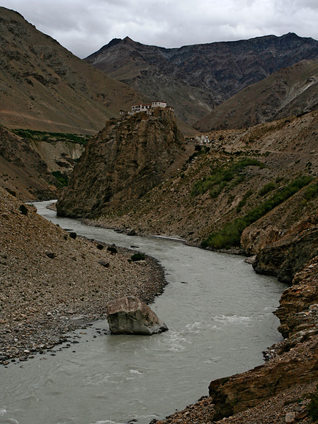
Bardan Monastery and Lungnak River
Just before the arriving at monastery, I see a tiny rodent that runs pasts me into its hiding in a wall built from rocks. I wait for it to come out, keeping my camera aimed at its hole. It sure does, carefully checking out for enemies from its safety. I take a few pictures, which later help me identify it as a Himalayan Pika. A few minutes of walking later, I encounter a white rumped swallow-like bird and a red-tailed bird, neither of which I am able to name.
It is not easy to convince myself that people actually live in these places. My GPS continuously recorded altitudes above 13,000 feet. We did not sight even one tree despite walking for hours together. The sun happily burned every inch of unprotected skin, peeling away flakes of epidermis. Oxygen levels were so low that climbing even a hundred feet felt like a day long arduous task. At times we climbed over 15,000 feet, where the thinning air laughed at our struggling bodies. Winter temperatures apparently fall twenty below zero or even lower. For the people of Spiti Valley, this was everyday life.
Before we started the long walk from Komic to Dhemul, Tenzin Lama, a monk at Komic monastery (altitude – 14,700 feet) said it takes about two hours. “We normally start after lunch,” he mentioned casually, “and walking slow and easy, we reach Dhemul (altitude – 14,200 feet)well before dark.” He was trying to assure us that there is absolutely no need to hurry, or worry about the walk. While he talked, he was making Maggi and tea for all of us – an early lunch before we begin the long walk.
We had an amazing variety of estimates on the time it takes to reach Dhemul. Tenzin’s was the shortest, and he made it appear like a child’s play. The man who suggested us to make this walk had estimated five to six hours. The guide who accompanied us — Thekpa — was more cautious. He was watching over us and had assessed our strengths better. He thought we will require about eight hours.

Lama Tenzin offered us tea and maggi before we embarked on the trek
It was eleven in the morning when we began conversations at Tenzing’s cozy little room at Komic Monastery. He was a cheerful chap who never seemed to stop talking, occasionally offering weird poses for our trigger happy group. When someone aimed the camera at him making tea, he would stand on one leg, other leg dangling in the air and his hands mimicking someone pouring tea from a kettle into a cup. The gang loved him instantly.
The good times lasted only as long as we were having Maggi with Tenzin. The struggle for oxygen began soon after we left Komic. On ascents, no matter how gentle it was, every step seemed like an attempt to carry a big ball of steel tied to the shoes. Descents were much bearable, but much of our way that day was a gradual climb. The views however, were something that justified the effort. Whenever we paused and looked back, Komic village appeared like a bunch of match boxes against a gigantic line of mountains that challenged the sky.

Komic was a small dot on the landscape. The snow-capped Chau Chau Kang Nilda Peak dominated the views.
With very little precipitation in the previous winter, many of the peaks far behind the village were unusually bare and brown. The tall Chau Chau Kang Nilda rose much higher than its neighbours and wore a shiny white that was worth the envy of its counterparts. On the opposite site, the mountains plunged steeply for more than two thousand feet into the valley of Spiti River, rising again to form another chain of snow-capped peaks. But most importantly, ahead lay a path that seemed to keep going upwards forever!
It must be about two hour’s of uphill journey before a short descent made a kind appearance. After the descent was a plateau-like area, full of a variety of thorny plants that had carpeted the earth. Thekpa, our guide, said that all those plants will begin flowering after the first rains in August and the earth turns purple with the efflorescence. The plants were so numerous and widespread in the plateau, it would be worthwhile coming here again to fill that scene in the eyes.

From the highest point of the trek, Dhemul Village appeared like a small spot trapped in the mountains.
After a short break and a short eat at the end of the plateau, it was time for a long and final ascent. It was nearly 5pm when we reached the highest point of the trek at 15,700 feet. Beyond the pass, we could see Dhemul village as a small spot trapped in the mountains. Now, it was a steep descent that we estimated to be a twenty minutes walk. The ever-cautious Thekpa suggested an hour. It turned out, he was right.

So near, yet so far. We thought it takes 20 minutes to get to the village. Our guide Thekpa suggested an hour. He was right!
We reached Dhemul at 6pm, a walk that took us a total of seven hours that included an hour of careless gallivanting off the path. Thekpa’s estimates turned out to be more reasonable than Tenzing’s.
Dhemul, much like Komic, was a village that appeared out of nowhere. It is amazing how people sustain in these villages, high up in the mountains and faraway from every other place. A hundred years ago when they weren’t touched by modernity, they lived an almost self-sustained life with the help of their flock of animals and subsistence farming. Sheep and yak provided them with milk, butter and meat while the barley fields gave them cereals. The fields are usually spread very close to the village and the villages are usually located next to a perennial stream that never dries up. Perhaps only salt and spices had to come from outside, may be from a long southern route via Kinnaur Valley. Their houses too, were built with locally available materials. The walls were of mud, while the roof was held in place with poles of willow that were grown all around the village. Every village in Spiti has a similar ecosystem, which looks like a verdant escape in the otherwise desert landscape.

A starry night at Lalung Village
Today, many of these villages are connected by road. A road is perhaps the most important thing that changes the lives of people forever. People still rely a great deal on their yak, sheep and barley fields. But they now have access to comfortable clothing that comes from outside, get to sleep in more comfortable mattresses, cook with LPG, eat rice and wheat besides barley and buy vegetables that they would never have access to earlier. Electricity poles too have made their way to many villages. Power supply is limited and erratic and is often backed by solar panels, but more often than not, people can cook their dinner under a bulb watching television. A more recent phenomenon – direct to home television – has invaded the homes rapidly, thanks to the receivers given away by Prasar Bharati.
Despite all these modern comforts having arrived in Spiti, I still can’t stop wondering how people ever lived here. The extreme weathers and limited resources still governs their frugal and efficient lifestyle. In the last two decades, Spiti’s Villages have routinely broken several records, such as the highest village in the world with permanent habitation, highest village with motor roads, highest village with access to electricity, highest fuel pump in the world, highest village with a post office and so on. While we get to hear about some of these statistics at every turn, not every one of them may be necessarily true.
Perhaps these harsh conditions of living have made Spitians understand human sufferings better than anyone else, and be of assistance to everyone in need. At the village, after we had comfortably settled in, I realized that we did not know where our guide was staying. An attempt to look for Thekpa alerted the entire village and the news spread quickly to wherever Thekpa was, who came to meet us. The moment someone got to know, several villagers had gone looking out for him, taking up the task as a personal mission. Later that night, the kind lady of the house took out the best vegetables in the house (aubergines, at 14,000 feet) to make our dinner. The villagers took care of us like a bunch of old relatives who were visiting after a long time.

These girls posed for a picture at Lalung Village.
The next morning, we were scheduled to make another long walk – this time thankfully downhill all the way – to Lalung Village (altitude – 12,300 feet). But the news had arrived that the annual festival at the monastery in Ki Village is scheduled on the same day. We changed our plans and boarded a vehicle to Ki, spent the day at the festival and took the road to Lalung Village in the evening.
The festival deserves another complete post, but the images and a brief report is available here – images of festival at Ki Monastery.
You will curse yourself for having decided to do it. It is not the most pleasing thing – to have to get down at 4.30am from the cozy and warm seat of your luxury bus in the middle of the nowhere. If cutting off your sleep was not enough, noisy loudspeaker from the chai shop blares a song from the latest Kannada movie and pierces your ears. If you are still sleepy and hope to catch some shuteye at the chai shop, you will be bitten by the cold morning wind – hard enough to forget your sleep forever. It is still not morning and you need to kill time, so you order for some tea, which is nothing more than sugar syrup in brown color. Time moves slowly as you order idlis and eat them grumblingly with the cold chutney.
We were on our way for a trek to Edakumeri – an abandoned railway station in the heart of the Sahyadri Western Ghats, between the towns Sakaleshpura and Subrahmanya. Surrounded by thick evergreen forests and countless number of streams running down the mountains, it has long been known as a picturesque place by the railway tracks, visited and admired by many. And when the trains stopped plying 10 years ago, it became a paradise to nature lovers who came seeking solitude and enjoy the beauty of the nature. The abandoned station offered refuge from the cold of the night.
We climbed up to the nearby Munjarabad court after tea and breakfast. The fort is nothing more than a short elevated enclosure on the top of a hill, known to serve as a watchtower. It was 5am and dark yet. Cold of the morning kept us awake. As we watched from the fort, we witnessed a short meteor shower, with occasional streak of light dropping down once in a while. The falling stars in the silence of the morning were broken by the early sunrays after a while. We started off on the trek soon after the sunrise.
Donigal village is where we had got down the bus and where Munjarabad fort is located. Not all buses stop here and sometimes you may have to get down at the previous town – Sakaleshapura. A brief walk down the road from Donigal and you hit the railway tracks. We hopped on to the tracks and continued the journey. Initial walk took us through villages in the middle of forest and sometimes fields. An hour of walking and you will not see people any more. All that you have is thick vegetation that is bifurcated by the railway tracks you are walking on. Do not make the mistake of asking any villager with the question – “how far to Yedakumeri”. You will come with varied answers, none of which could be close to reality. Here are some samples.
“May be 4-5 kilometers. You should reach there in 2-3 hours”
“We villagers never bother to walk on these tracks, I don’t know. May be a few hours of walk”
“Don’t go there. There are elephants in the forest!!”
“10 kilometers. You should be able to do it before noon”
“Why are you going there?”
But it is difficult not to ask them time and again; curiosity is a real killer. Take the answers with a pinch of salt and just have fun with it instead of assuming them true!
It is not surprising that most villagers would not have known the real distance, because they would never have walked the way. They live in these beautiful forests, interact with it every day, use the water of the streams and the produce of the forest for their livelihood. The beauty gets taken for granted when you have spent all your life there. A villager asked me how did I feel about his village as we walked past. I said – beautiful, and said would not mind settling down here, had I had a means of livelihood. He casually remarked that while he would do anything to get to the city and find a life there, we talk about just the opposite. It is a sad truth, but reality too. It is difficult for us to find livelihood in the village and we never move out, but they sometimes find some work in the city. The cities are getting crowded like never before since they offer endless opportunities. Its seems like a natural phenomenon in the new economy and is difficult to pinpoint blame on anyone.

The railway tracks running through the forest
A few hours walk and the jungle gets thicker. The flat terrain gives way to hills, and streams appear in the intersection of these hills. These hills and streams are in plenty, and this geography has resulted in creation of many tall bridges and long tunnels for the tracks. They are a prime attraction of the trek. There are bridges and tunnels that are almost a kilometer long. Bridges can be really high from the valley floor and are definitely not for the acrophobic(People with fear of heights). And the tunnels tend to be pitch dark and infested with bats, certainly not for those who fear darkness. The total walk can be anywhere from 10 to 16km to Yedakumeri – so some fitness is necessary to make the walk.

Walking on the bridge
The bridges offer open and beautiful view of the valleys. Sometimes you can walk down the bridge and get into the streams, and take a dip in the clear and cold waters. You will also see water gushing down like a shower from openings in the tunnels, which serve as a refreshing shower if you are tired of the walk. We once made the walk in the middle of the monsoon, and the seeing water everywhere is a joy. You wade across the streams that seem to intersect with the tracks. The tunnels are always sounding with flow of water. Everything you see is wet, wet and wet. Its usually pouring day and night and you have to be either very well prepared or be ready to get completely wet. We had both: we were well prepared and yet we were ready to get completely wet and enjoy the rains.

Rocks, water, forest and the tracks
By around 11am, you are somewhere in the middle of the journey. You have really enjoyed the beauty of the green Sahyadris. The valleys to your right, where you can hear the sound of the streams, or the mountain slopes rising beyond the valley seem to have enriched your soul. You will love the thick forest cover visible all the way till the horizon and enjoy the occasional mist(if you are there in the monsoon) in the distance merging itself with the cloudscape. The trouble of broken sleep and the cold morning are forgotten and you feel blissfully happy. This is the time when your body begins to complain lightly, lead by the legs that are beginning to feel overworked. Add trouble with your back if you are carrying heavy luggage. This is when you will start wondering again and again about how far to go. You rest for a while and walk, rest again after seeing nothing ahead and keep limping forward. It seems to be a long way, and it actually is. By the time you arrive at the destination, it is usually around 2 to 3pm, and you would have walked more than 10kms. You are really tired, and after a quick bite for the hungry stomach, it is a good time to rest, and take a nap if you want to.

Emerging from the tunnels… One of my favourite images ever, I titled it “Tamasoma Jyotirgamaya”(from darkness to light)
By the time you get back your energy, it is 5pm. The pleasant evening encourages you to explore around. You look at the old abandoned railway station, which is almost destroyed by time. The valley below is deep and you don’t get to see much. A few hills are on the other side and are enveloped by tall trees or green grass. Weather is pleasant and you will unknowingly start humming your favourite song, which is occasionally disturbed by hum and honk of the vehicles which are far away somewhere in the valley. The sun moves beyond the horizon and you are back to this world, in your shelter, and ready for another intake of food. You
indulge in some good chat to recollect the proceeds of the day. Sleep doesn’t come early despite being tired, but when it arrives, it is deep and undisturbed sleep.
Most trekkers leave on the next morning, but those who stay on to explore are the most fortunate. There are plenty to see. Birdwatchers from the city may see many species that they have never seen in the planes. There are a couple of streams and waterfalls around the station that are worth visiting. Those who don’t mind walking further can climb up the hill for an hour or so more and enter the meadows at the high hills nearby, enjoy the full view of the valley and feel the breeze on the top. We once went to a village on the top of the hill which is located in the high grass lands. We walked beyond the village into the grass laden higher hills and visited a small watch point(often called fort) which is known to be built by Tipu Sultan’s army. There is a long bridge followed by a very long tunnel just after the station. I still remember the fun of standing under the gushing water which worked as an excellent rejuvenating shower after coming back from a tiring climb.

We found this snail on the tracks
The way back seems most difficult. You have enjoyed the journey and seen the best, but you still have to walk more than 10kms to return to civilization. It is painful and tiring for the already tired body, but there is no choice. You have an alternative if you come late in the winter or during the summer. You can walk down 4kms into the valley, wade through the river Kempu Hole which flows below and reach the road and hitch a ride. But the best time to be in Yedakumeri is during the monsoons when the river is swollen and impossible to cross. You carry the pain and tiredness even after you get into your bus, and reach the city. The pain vanishes in a few days, but the memory will stay forever.
I have been to Yedakumeri 5-6 times and this write-up is a combined experience of all the trips, which I have done in various seasons. Though I feel monsoons are the most beautiful time to be there, it is difficult to get there in the rains. At the time of writing, the railway line and the station which were abandoned are in the process of recommissioning. Trains are running on the tracks on trial basis. The station may no longer be as isolated and calm as it were, but its surroundings will definitely retain the same beauty as they did(even though you may see more people and more garbage there!)
YEDAKUMARI INFORMATION
To reach the place, take buses plying from Bangalore to Mangalore. If you take the night bus, you can reach early in the morning. You need to get down at the last town where the bus stops – Sakaleshapura. The trek starts from a small village called Donigal. Take a local transport to Donigal village, which is a short trip further on the Bangalore to Mangalore road. Some buses from Bangalore may stop at Donigal on request, but ask in advance. Otherwise you may be able to hitch a ride from a friendly truck driver who would not mind some extra buck. Those who know the route well get down much ahead of Donigal and then get into the track to reduce the total walking distance.
The trek itself is around 16km if you start from Donigal. It takes around 6-8 hours to complete. You could take shelter in the abandoned station then, but unlikely it is abandoned now. But if you have a sleeping bag and/or a tent, you may be able to manage. Those interested can head further next day on the track to reach next station Sirivagilu and then to Subrahmanya and then return by road. But there is much to explore in Yedakumeri and I advice to stay there for another day.
There are other options for the return journey. Late in the winter or during summer, you can walk down the valley and reach the Bangalore – Mangalore highway after walking for an hour. But this option is ruled out in monsoon since you won’t be able to cross the swollen river on the way. Another option is to head to a village up on the hill and find further transportation to Sakaleshapura. Note that either option will require help from someone who knows the way.
A short detour in Donigal village will take you to Munjarabad fort. Note that these days you have to wait till 6am to get into the fort, since the doors will be closed before that. We had the luxury to get into the fort at 5am once and watch from the top the arrival of the sun, but that is no longer possible.


