Rohtang Pass is a place that marks many divides. To the south are the green slopes caressed by monsoons every year and to its north is a stark landscape often called the forbidden valley. Beyond Rohtang, the landscape begins to start resembling Tibetan, and so do the people. Temples give way to monasteries and Shiva makes way for Buddha. Apple orchards are replaced by potato and sweet peas. It is as if you just changed the DVD and a different movie started playing on the gigantic 16:9 screen.

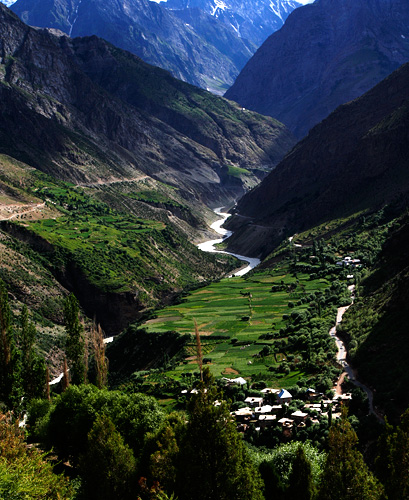
The fabulous setting of the town of Keylonw, Bhaga River and the road from Tandi
People north of Rohtang have an unusual pride about the altitude they live in. Every village along the way lays some special claims about its location. In Spiti Valley, a deviation on the Leh highway, people at Kibber Village once loved to call it as the highest permanent inhabitation in the world. When the record was broken somewhere else, they were not ready to give up. They came up with more possibilities instead: highest village with electricity, highest village with a motorable road, highest village with a post-office, and so on. A quick web search reveals all possible versions and may even give ideas to cook up new ones. Just below Kibber at the base of Spiti Valley, the petrol pump in Kaza doesn’t fall behind in making the ‘highest in the world’ claim.
Going past Keylong, probably every named place has something highest attached to it. It is only a matter of finding out highest ‘what’!? Indian Army takes bulk of the credits for creating all these highest hypes. In Pang, a tourist stopover on the way to Leh, is an army camp labeled as the “world’s highest transit camp.” Far north in Ladakh is Siachin glacier with its notorious claim for being the world’s highest battle field, where India and Pakistan have been fighting and wasting away lives and resources for a land that neither party can put to any good use. Once you have the privilege of making claims for world’s highest battlefield, the highest airfield is obviously not going to be far away. And Khardung-la, the world’s highest motorable pass doesn’t need any introductions. But Khardung-la’s days are probably numbered: everyone speaks of motorable passes in Ladakh and Tibet that raise much higher. I am sure they will find a new title for Khardung la when another pass officially becomes the highest motorable road.
That’s much digression from Rohtang Pass where we started from. It is a quick and steep descent from the pass, down to the valley of Chandra River. The small village of Khoksar next to the river is more a food court than a village. Dhabas line up the 100m or so length of the road, which is as long that the village spreads. A Himachal Pradesh Government PWD bungalow in the village may be open for visitors, but most people prefer to continue to Keylong. Despite the charm of Chandra River, Khoksar is not a pretty place and is too close to Manali for a halt.

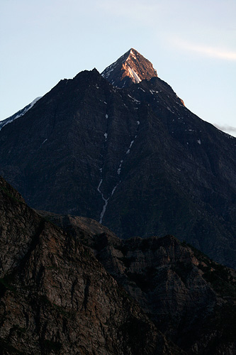
Mighty mountain peaks seen from Keylong town
The way further is parallel to Chandra River, going downstream after crossing the river at Khoksar. It is usually muddy and flows swiftly in the months of July and August – the peak season for travelling to Ladakh. Photographs taken in later months show it in a deep hues of blue, a color that eludes most people who are on their way to Ladakh. The tall peaks along the way tend to have last snow of the season, and many tall waterfalls come down from the steep hills to merge with Chandra.
Tandi, 10km before Keylong has the last petrol pump on the highway. The road here turns right and continues along the valley of Bhaga River. A sign at the confluence of Chandra and Bhaga reads [not verbatim; recreated from memory]: “Welcome to Tandi, the confluence of blue waters of Chandra and green waters of Bhaga.” Unfortunately, the colours are all mixed up with plenty of earth, and what is there to see is two muddy currents coming together into one.
Chandra and Bhaga have an interesting origin. They both begin at different faces of the mountain at the same location – Baralach la. Chandra flows east and then turns west traversing through the valley of Lahaul, while Bhaga flows south through Darcha and Keylong. They meet again in Tandi, like two long lost sisters getting to see and hug each other. More like we see siblings separated at birth rejoining in an emotional drama in a Kannada movie, with the lead actor playing two roles.
Keylong is a quick 20 minutes drive upstream Bhaga River. It is the place where most people prefer to spend the night on the way to Leh, as we found out on arrival.
One of my long standing dreams has been to swim in the Ganges.
I have been along the Ganga in various stages of her flow. When she is a youthful energetic self – agile and swift when coming down from the high mountains in Garhwal, below the snow line where she is colored turquoise in the wooded country and meanders through the mountains – much softer but still quick and seemingly in search of the plains, in Rishikesh where she widens her path and looks to stray from her channel that has remained narrow so far, and in Haridwar where she still retains her energy and purity as she cleanses thousands of pilgrims in the bathing ghats.
Map: Course of Ganga
She remains charming as ever all along and each time I step close to the bank, I am driven by an irresistible urge to jump in, swim along her course for a few miles and feel like the river myself. It has been a dream for many years now, since the first time I set sight on her in Rishikesh.

Ganga at Rishikesh
The dream has remained unfulfilled, there was always something that held me back. She is a wild torrent and the water is frigid up in the mountains. She looks deep and just nice enough to float along with her in the mountains upstream of Rishikesh, but still flows fast and appears hostile. Ganga’s river bed has been reduced to a trickle in Haridwar by a dam and the swift currents in the narrow canals are not meant for swimming.

Ganga at Varanasi
I had my hopes on Varanasi. I knew she would be mild here and take her time to push through the plains to the ocean. I knew she would be deep enough that the river bed never runs dry in these parts. I had heard of its polluted waters but hoped it would be fit enough at least for a swim. I was eager to see the Ganga on my first visit to Varanasi.
But when I went there, the sight of Varanasi’s ghats was depressing. The river was not just unclean, but looked no different from a sewer. It was dark, nearly opaque and was filled with floating organic mass along the bank. At Assi ghat where the river makes a slight bend into the west bank, disposed trash made a thick layer that completely covered the surface. Forget swimming, even touching the water seemed unthinkable.
But pious pilgrims who arrive here seem to be unmindful, which surprises me. Their faith must be a really strong to be able to callously step into the murky river and be at ease during the ritual bath.
A friend who was recently in Varanasi was taken aback by the response when she asked someone if they are not troubled by the pollution in the river.
“Ganga is intrinsically pure,” she was told, “there is no way it can be polluted, no matter what gets mixed into it.”
‘Ganga Ma’ was loved as is, no matter what state her waters were in. But I had met a few people who were more concerned. A man I was speaking to who was on a pilgrimage was deeply concerned. “You must be feeling sad about all that is happening to the Ganga,” he told me, “see what we are doing to our mother.”
Despite seeing hundreds of people taking a dip or go swimming in the river, I did not have the courage to jump. When I returned from there, my wish remained unfulfilled. I shall be going back to Rishikesh some day, and when I do, I shall go rafting and drift down the river and hopefully get to swim in it’s friendly stretches.
Travelling in Himachal in June – 2007
Shimla >> Manali >> Rohtang >> Chandratal >> Ki/Kibber/Tabo >> Kalpa >> Shimla
+ Previous: Driving to Batal
+ Next: Kunzim La, Kaza, Ki Monastery and Kibber
+ Go to beginning of the story or index page
The night in the dhaba at Batal was comfortable. I was expecting it to get cold in those altitudes, but it was not bad at all. We did feel a little cold with the blowing wind outside but hardly anything of Himalayan scale. The days were in fact warm to hot and the temperature seemed to go beyond thirty degrees. I woke up early in the morning taking advantage of the fair weather. Sun was still invisible and beyond the mountains, but the first rays of the day were already on the distant mountain peaks that raised much above us, even we were still in shadow. Standing on the bank of Chandra River, I spent an hour photographing those sunlit mountain peaks scurrying from place to place and re-adjusting the tripod, lest I miss those beautiful moments before the sun rises high. But at the end of it, I felt a loss – a loss of not witnessing those pristine moments quietly sitting next to the river.

Chandra river flows in its valley


Early morning at Batal

We had a quick breakfast of greasy but delicious Aloo Parathas and made our way towards Chandratal. It took us more than an hour’s drive to get there and it was the most dangerous road we drove through in the entire journey. The road was sometime narrow just enough to let our jeep pass, and any error in judgment would simply mean a plunge into the river. Some U turns were steep enough to require us to do a few iterations of forward-reverse to pass through. But arriving at the Chandratal, we could see all that effort was worth it. It is a long, turquoise colored water body with cold and clear water. Its surface was calm and reflected the snow-capped mountains and clear blue skies. We spent a few hours walking on the lake shore and enjoying the dramatic setup of the lake amidst the mountains.

On the way to Chandratal


Chandratal..
Continued at Kunzim La, Kaza, Ki Monastery and Kibber


